An old boss of mine says unintended consequences is merely the failure to adequately consider the implications of the decision being made.
The location of the Bridgwater Tidal Barrier (BTB) is probably the most significant decision Sedgemoor District Council has made in many years. Rarely can such an important decision have been made with so little debate. If it’s in the wrong place we and the following generations live with the consequences for the next 200 years or so. No one is giving us another one if its wrong.
On the 26th July 2017 a full Sedgemoor District Council meeting agreed the location of the Bridgwater Tidal Barrier. This decision according to the minutes was apparently waived through without discussion. That the EA and SDC gave a superfical 3 page briefing document with so few key facts indicates just how confident EA and SDC officers felt able too simply ignore the longer term collateral environmental and economic impacts of this scheme. It is a clear indication of the low esteem our councilors are held in. Councillors lack of oversight of this scheme does indicate the officers probably wernt wrong. Silent oversight committees seems to have presided over continued and unsatisfactorily explained cost rises. The cost almost doubled in the the six months after the decision was made. Barely a word was said.
The Issue
Abandoning 1,400 acres of valuable land next to a motorway junction capable of supporting £1B of future investment (jobs) whilst unnecessarily forcing future housing onto the Quantocks foothills extending Bridgwater to absorb Cannington, Spaxton and North Petherton.
This decision will be seen as one of the most irresponsible and reproachable acts by councillors of any local authority at any time. SDC knowingly made a decision to convert the Parrett Estuary into an Intertidal Habitat and behind the the secondary flood defence create more areas of habitat suitable for freshwater mosquitios such as the Zika and Denge carrying Asian Tiger Mosquito to take up residence.
Limiting economic expansion, building on the Quantocks, poisoning the fresh water ecology of Chilton Trinity and Pawlett Hams and creating a future health hazard is hardly what we people voted councillors into office for.
- If they did know why did they do it?
- If they didnt know why not?
Why is this case?
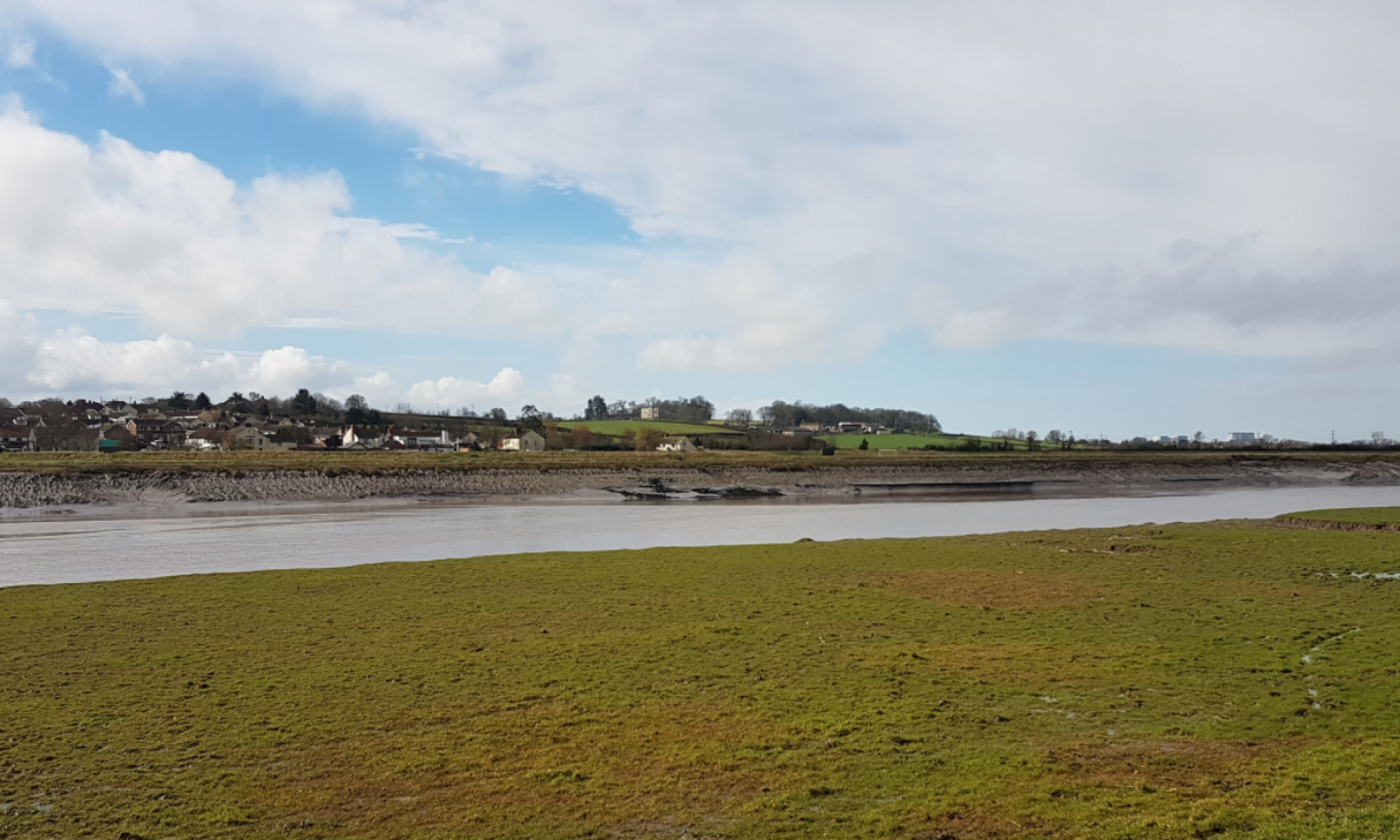
The BTB design uses farmland downstream of the barrier to allow incoming saltwater to spill over riverbanks onto the farmland. It destroys the economic value of around 2.400 acres of land either to continue as low-grade farmland or 1,400 Acres of that total to the south of the Parrett providing land for nearly a £1B of economic development accessible from J23. Would any town throw such an economic legacy away with so little concern? Bridgwater has. The longtime environmental Impact of this scheme is equally as bad; the land being flooded will ultimately become saltmarsh and a large part of the local Quantock foothills unnecessarily developed
The December 2018 public consultation asked for feedback on three basic points
- The details of the proposals for both the barrier and the downstream flood defences.
- How you think the proposals may affect you, your land or your business.
- What additional improvements you would like to see delivered as priorities, in addition to the barrier and the downstream flood defences, subject to funding.
Context
Large civil engineering projects influence long-term economic development as we have seen with development taking place around our motorway junctions; the proposed Bridgwater Tidal Barrier (BTB) will influence Bridgwater’s future development in a similar way for at least the next 200 years. The Bridgwater Vision published in 2015 and referred to in the presentation identified land for future development most of which is either now approved or starting to be built out under the local plan. Bridgwater is already reaching the limit of land that can be easily accessed from the town and the M5.
Assuming Bridgwater continues to develop economically at even half its present rate, during the design life of the BTB, an additional 25,000 houses will be built and together with land for employment and Bridgwater’s footprint will grow by around 40%.
Under the present BTB scheme low quality farmland directly beside Junction 23 that could have provided space for at least £1B of economic development, housing and jobs will be lost to the town. Alternative land over the next 100 years will need to be found and that will invariably mean development moving on to high quality agricultural to the south and west of Bridgwater. We will build on the land that feeds us whilst living ever farther from planned and established centres of employment to the north and north east of Bridgwater (Horsey). Building at Horsey will require a new bridge over the King Sedgemoor Drain; money that could be used to cross the Parrett and bring forward a much needed northern bypass.
Location
The reader should take cognisance that the two options studies done for this scheme, the first included highly improbable options such as the Bridgwater Bay power lagoon and outside the influence of the authors. The second option study looked at the same solution at a limited number of locations and would always arrive at the narrowest part of the riveras the prefered solution. It was a superficial study and lacking rigour and at the time of this note the final information used by an SDC sub group remains unpublished despite an FoI request to Sedgemoor District Council remaining outstanding.
Other options and locations to protect Bridgwater and the downstream villages were available but not considered.
Description
The Bridgwater Tidal Barrier is a 7mile long inland tidal surge flood defence scheme with a 100 year design life based on sea level rising around 800mm during this period. Similar to the current Thames Barrier it consists of two elements.
- Riverbanks profiled to preferentially spill seawater, during extreme tidal surge conditions, onto farmland at Chilton Trinity and Pawlett Hams.
- A small double vertical floodgate barrier located in the industrial and employment Express Park area of Bridgwater and approximately 1 mile from the town centre.
The replacement Thames Barrier will be sited more conventionally at the mouth of the Thames; Combwich is Bridgwater’s equivalent location.
Key features
- The riverbanks are expected settle and need reconstructing every 35 years
- The height to which the riverbanks can be raised is limited by the poor ground conditions.
- Although needed no provision of any kind for a replacement is considered.
- Contaminates around 2400 acres of farmland with salt water
- Constrains economic development to the northwest of the town.
- Significant loss of existing freshwater habitat in line with managed realignment policy 7d39 of the Shoreline Management Plan to create an intertidal habitat.

Operation
The closure of the barrier at low tide creates a separation of the two types of water that use the River Parrett. Upstream freshwater from the Parrett and its tributaries such as the Tone; Yeo and Cam will be impounded behind the closed gates. Downstream the freshwater will finish emptying into the Severn and the then the empty river filled with seawater on the incoming tide.
All flooding shown downstream of the Bridgwater Tidal Barrier will therefore deposit salt water onto the land. This is saltwater and the impact should not be confused with the 2014 event.
The land in question at Chilton Trinity has not been flooded with salt water in this way within living memory. Pawlett Hams was briefly flooded in the early 80’s and flooded Pawlett from the north where no flood defences are planned.
Summary
What is clear is that considerable ambiguity remains in the proposal. Many issues are simply ignored or the messages contradictory. The following summary and notes provides some comments that should be addressed.
It is disappointing that such an important scheme appears to have been given so little strategic thought whilst the barrier appearance and immediate landscaping seems to have received considerable if unsuccessful attention.
Clearly the priorities of the design and client team are not those of the ratepayers who do not need a solution where the medicine kills the patient which is what we appear to have.
River Banks
One consistent underlying theme is that once the barrier is built the land to the north and south, Chilton Trinity and Pawlett Hams, will ultimately become intertidal habitat in line with existing published policies.
The key supporting facts are
- The cost estimate that does not include for future riverbank reconstruction
- Planned flooding of agricultural land with saltwater.
The claim made “Bridgwater and the surrounding area will be better protected against a severe flood by building the barrier and improving the downstream flood defences. These works will also maintain the current standard of defence to agricultural land”.is misleading to landowners indicating that farming will simply carry on as normal. With the frequency of saltwater flooding increasing the land will not support the type of grass needed for agricultural. Areas of Norfolk are still recovering from single sea water incursion 65 years ago.
Borrow Pits
No location for the pits was given, which side of the secondary flood defence. It would not be unreasonable to assume between the river bank and the secondary flood defence. A rough estimate would indicate that the scheme will need around 100,000m3 to 150,000m3 of clay creating a large open area (7-8Ha) of stagnant water that will through our now warmer summers become more saline as they will operate as a large evaporation pond. That mechanism does not allow the wildlife enhancement described to occur.
Locations were shown to stakeholders but not the public
Environment
A number of claims are made regarding the lack of environmental impact that this scheme has on the ecology however changing the habitat from freshwater to saline will fundamentally change the area in line with the published strategy of changing the land to an intertidal habitat.
2,400 acres of fresh water habitat is destroyed through repeated seawater flooding.
Cost or Intention
An estimate of £94M is given in the EA presentation. Through a FoI request (03 April 2018) The EA provided an estimated whole life cost closer to £160M. That estimate assumed £12.4M Net Present Value or £55M cash cost over 100 years including for maintaining and rebuilding the riverbanks that is around 4x the value of the land. Economically this statement on maintenance costs makes funding the future bank rising impossible. If the circa £100m estimate is correct this would cover the gate maintenance and not the riverbanks.
The expected need to rebuild the riverbanks twice in the 100-year design life is not mentioned in the presentation and the assumption must be that the intention will not become reality and would conflict with clauses 1.10.1 and 1.10.2 of SDC’s Parrett Estuary Flood Risk Management Strategy
The whole life cost of the scheme is either
- £100M with one set of the riverbank improvements at the time the barrier is constructed.
- £160M with three sets of the riverbank improvements including the time the barrier is constructed and subsequently at 35-year intervals after that. That must be the budget.
Did nobody ask why?
Collateral Impact
This scheme is presented at completion in 2024 and looks only at immediate local impacts. Construction will have immediate and long term wider negative consequences for Bridgwater none of which have been raised or addressed despite written assurances that that would not be the case.
Economic Impacts
- Loss of 1400 acres of key land suitable for £1B of economic investment for housing and industry that is directly accessible to Junction 23.
- Creation of a working flood plain over which a potential bypass might need to be constructed.
- Increasing separation of housing from employment by forcing development elsewhere.
- Loss of economic food production on prime agricultural land
- The loss of in existing land values of around £12m and potential bankruptcies where the land is used to secure business loans.
Environment Impacts
- Destroys 2400 acres of fresh water habitat through deliberate seawater flooding initially during extreme tidal events but ultimately becoming within the normal tidal range.
- Forces development to take place on high quality agricultural land to the south and west of Bridgwater.
- Forces apart residential and employment areas with a consequent long term cost to the economy and the environment.
- Places increased demand on the A38, A39 and Kings Drive as industrial development is forced east to Horsey and to the approved BAE industrial site.
Barrier Superstructure
The barrier superstructure is 2 to 2.5 times higher than it needs to be and lacks any shape that reflects its functionality. It achieves the rare combination of being both pretentious and mediocre. With a structural volume that must be four times what could be reasonably required to support its function it is bloated, unnecessarily expensive and will be difficult and expensive to maintain. Overhanging shapes require specialist access equipment for maintenance. Everything on the structure seems designed to cost more than is necessary. Its appearance seems to owe more to Mr Blobby and the Teletubbies than the Falkirk Wheel, it doesnt do anything like the Falkirk Wheel so hardly a tourist attraction.
The very large ovoid bridge structure will be particular difficult to maintain, it will be almost impossible for safe inspection of the lower quadrants to be made or worked upon. The form of the structure indicates little attention appears to have been taken with regard to the Construction, Design and Management 2015 regulations with regard to the safe operation and maintenance
The poor design of this structure extends to the gates, rather than protect the gates from the salt loaded wind driven rain, the site is classed as a marine environment, rain will be spilled from the ovoid bridge onto the gates increasing maintenance and reducing the life of the gates.
As a piece of architecture and a piece of engineering this structure almost certainly fails on cost, function, operator safety and buildability.
Storage Buildings are provided when the EA has a depot nearby at Bradney.
- Did no one ask why we need additional buildings at the barrier site?
- Presumably they would also attract rates?
Sustainability
The lack of sustainability in this project is very concerning;
The decision to excavate burrow pits to reduce construction traffic seems highly questionable. “Where possible, we will excavate material locally from ‘borrow pits’. This will minimise the need to bring in material to build the new downstream flood banks and reduce construction traffic.”
The EA was more than happy to bring excavated material from its Cannington flood project to Chilton Trinity yet the more sustainable option of building the banks over a longer period using spoil from building sites is not considered. It’s not as if the defences need to be at their final levels until the last planned rebuilding of the banks 35 years before then end of the design life. This work could be done on an opportunistic basis over the next 50 years or so in a sustainable cost effective method by local contractors.
The continuing reference to 2055 that is key date in the shoreline management plan indicates thatany future raising of the river banks is unlikely to occure.
This process would also assist in maintaining accesses and local resources able to respond to urgent requirements such as a breach in the river bank.
Finally just to prove the point the EA/SDC presented on page 7 of the stakeholder presentation three images of unrelated events to support its postition.
- West Quay collapse, an old wall collapsed when it got too much water behind it; we see thse failures alongside our roads all the time but we dont try and link them to climate change or a tidal barrier.
- The 2014 flood was a pluvial (rain) event and the Bridgwater Tidal Barrier is not designed to mitigate a repeating event. There is clue in the word Tidal. Unfortunately many people in Bridgwater and the surrounding area believe that it is part of a pluvial flood defence scheme.
- one was applicable

Perhaps an SDC, Town or county councillor reading this might decide to ask some serious questions about this project, one can only hope.
You must be logged in to post a comment.